
Author: Nabarun Academy
Competitive exams (W.B.C.S / U.P.S.C)

WBCS Prelims Syllabus 2025
| Subject Name | Marks | Questions |
| English Composition | 25 | 25 |
| General Science | 25 | 25 |
| Current events of National & International Importance | 25 | 25 |
| History of India | 25 | 25 |
| Geography of India with special reference to West Bengal | 25 | 25 |
| Indian Polity and Economy | 25 | 25 |
| Indian National Movement | 25 | 25 |
| General Mental Ability | 25 | 25 |
| Total | 200 Marks | 200 Questions |
WBCS Exam Pattern:
- Questions of the Preliminary Exam in WBPSC WBCS will be of Multiple Choice (Objective MCQ) Type.
- Exam will be conducted offline.
- OMR Sheet will be given to answer.
- Duration of the Exam will be 2 Hours.
WBCS Main Exam Syllabus 2024
| Subject | Marks | Duration | Type of Paper |
| Language Paper | 200 | 3 Hours | Descriptive |
| English Paper | 200 | 3 Hours | Descriptive |
| General Studies – Paper I | 200 | 3 Hours | Objective |
| General Studies – Paper II | 200 | 3 Hours | Objective |
| Constitution of India and Indian Economy | 200 | 3 Hours | Objective |
| Arithmetic and Test of Reasoning | 200 | 3 Hours | Objective |
| Optional Subject (2 Papers) | 200 + 200 (For Group A & B) | 3+3 Hours | Descriptive |
বাংলা ভাষায় WBCS এর সিলেবাস
পশ্চিমবঙ্গ সিভিল সার্ভিস একটি অত্যন্ত গুরুত্বপূর্ণ প্রতিযোগিতামূলক পরীক্ষা। তিনটি ধাপের মাধ্যমে বিভিন্ন পদে প্রার্থীদের নিয়োগ করা হয়। এই তিনটি ধাপ হলো – প্রিলিমিনারি পরীক্ষা. মেন পরীক্ষা এবং ইন্টারভিউ. এখানে আমরা প্রিলিমিনারি ও মেন পরীক্ষার পাঠক্রম নিয়ে আলোচনা করব:
প্রিলিমিনারী পরীক্ষার সিলেবাস:
- ইংরেজি – 25 Marks
- সাধারন বিজ্ঞান – 25 Marks
- জাতীয় ও আন্তর্জাতিক গুরুত্বের বর্তমান ঘটনা – 25 Marks
- ভারতের ইতিহাস – 25 Marks
- পশ্চিমবঙ্গের বিশেষ উল্লেখ সহ ভারতের ভূগোল – 25 Marks
- ভারতীয় রাজনীতি ও অর্থনীতি – 25 Marks
- ভারতীয় জাতীয় আন্দোলন – 25 Marks
- সাধারণ মানসিক ক্ষমতা – 25 Marks.
মেন পরীক্ষার সিলেবাস:
- ভাষার প্রশ্নপত্র – 200 Marks,
- ইংরেজি প্রশ্নপত্র – 200 Marks,
- সাধারণ অধ্যয়ন: প্রথম পত্র – 200 Marks,
- সাধারণ অধ্যয়ন: দ্বিতীয় পত্র – 200 Marks,
- ভারতের সংবিধান এবং ভারতীয় অর্থনীতি – 200 Marks,
- পাটিগণিত এবং যুক্তির পরীক্ষা – 200 Marks,
- ঐচ্ছিক বিষয় (২টি পত্র) – 400 Marks.
W.B.C.S Mains Exam Instructions
- WBCS selection process mainly consists of three steps – Prelims, Mains & Interview. The mains is the second stage of selection.
- Main Exam is the toughest of all the three exams. Deep knowledge of subjects of a candidate is tested through the mains exam.
- The mains test is of 8 papers. Six are compulsory and Two are optional.
- To pass the mains exam, one must qualify the cut off marks. There is no subject specific cut off. Candidates have to clear aggregate cut off which is decided by the commission depending on the caste category.
- After passing the mains exam, interview round will be conducted. Candidates will be called for interview in order of merit list prepared after the WBCS Main result.

Welcome
Education goes beyond memorizing facts; it shapes the ability to think critically. True learning fosters curiosity, problem-solving, and creativity. A trained mind can analyze, adapt, and innovate for lifelong growth.
Edukate
Urban Geography
Urban Geography
Urban geography is a word derived from Latin language which is made up of Urbs+ that is town +town associated area.
Urban geography is a branch of human geography concerned with various aspects of cities.
Urban geography is the sub disciplines of geography which concentrates on those parts of the earth’s Surface that have a high concentration of buildings and infrastructure. Predominantly towns and cities, these are settlements with a high population density and with the majority fo economic activities in the secondary sector and tertiary sectors.
Dickison defines urban geography as the study of a city commanding the surrounding region.
Welcome
More Information
Education goes beyond memorizing facts; it shapes the ability to think critically. True learning fosters curiosity, problem-solving, and creativity. A trained mind can analyze, adapt, and innovate for lifelong growth.
Edukate
Related Post
Indian Geography

Indian Geography
India is considered a “subcontinent” because of its size. It is aurally a part of Asia. In the north are high mountains, the Himalayas and Hindu Kush. In the center is the Deccan plateau.
INDIA AND ITS SURROUNDING
Physical Aspects:
Southern most latitude of India: 06o 45/ North
Northern most latitude of India: 37o6/ North
Southern most latitude of Indian main land: 08o4/ North
Tropic of Cancer (23o30/ North) Passes through middle of India. It passes through the
following states: Gujarat, Rajasthan, Madhya Pradesh, Chhattisgarh, Jharkhand, West Bengal (Purulia, Bankura, Bardwan, Nadia) , Tripura and Mizoram
Ranchi is the capital city which is situated nearest to the tropic of cancer
Western most longitude of India: 68o7/East
Eastern most longitude of India: 97o25/East
Indian Standard Longitude: 82o30/East
Longitudinal difference between eastern most and western most place of India is: 29o18/
Local Time Difference Between Eastern most and Southern most Part of the Country is: 117 M 12 S or 1hour 57minutes 12seconds
Time difference between Indian Standard Time (IST) and Greenwich Mean Time (GMT) is: + 5 H 30 M
Time difference between Local Standard Time (LST) of Kolkata and IST is: + 24 Minutes
Time difference between LST of Kolkata and GMT is: + 5 H 54 M
Indian Standard Time is same with Sri Lanka
- · Indian Standard Longitude passes through the following states: Uttar Pradesh, Madhya Pradesh, Chhattisgarh, Orissa and Andhra Pradesh
- · Tropic of Cancer and Indian Standard Longitude intersect each other in Chhattisgarh
- · Tropic of Cancer and Indian Standard Longitude both passes through over Madhya Pradesh and Chhattisgarh
- · Distance between southern most point of India and Equator is 876 km
- · Northern most point of India (Administrated): Indira Col on siachen glacier in Jammu and Kashmir
- · Northern most point of India (Disputed): Dafdar near Beyik Pass in Jammu and Kashmir

· Northern most point of India (Undisputed): Dharwas in Chamba district of Himachal Pradesh
· Southern most point of India: Indira Point (Pygmalion Point) in Great Nicobar Island
· Southern most point of Indian Main land: Kanyakumarika / Cape of Comorin in Tamil Nadu
· Eastern most point of India (Disputed): Kibithu in Anjaw district of Arunachal Pradesh
· Eastern most point of India (Undisputed): Kumki in Changlang district of Arunachal Pradesh
· Western most point of India: Guhar Moti in Kachchh district of Gujarat
· Highest peak of India(Disputed): King of Karakoram (Godwin Austen) in Karakoram Range(J&K)
· Highest peak of India(Undisputed): Kanchenjunga on India Nepal border in North Sikkim
· Highest peak of India (Entirely in India): Nanda Devi of Garhwal Himalaya in Uttarakhand
· Lowest Place of India: Kuttanad in Alappuzha district of Kerala
Welcome
More Information
Education goes beyond memorizing facts; it shapes the ability to think critically. True learning fosters curiosity, problem-solving, and creativity. A trained mind can analyze, adapt, and innovate for lifelong growth.
Edukate
Related Post
Geographic Thought
Philosophical Approaches Positivism – August Comte Idealism – Harris & Guelke Realism – Gibson New or Critical Realism – T.P…
WB SSC SLST
At NABARUN ACADEMY, we believe in building a strong foundation for success. Our mission is to empower students with the…
M.A / M.Sc (Theory and Practical)
Why NABARUN ACADEMY?
We at the NABARUN ACADEMY are committed to provide a quality based education and most competent courses for our students, so that they can easily and confidently compete in the present scenario. We’re focused to enhanced both technical/practical and professional quality of our students’. We are committed to provide a healthy and competitive environment with all the required facilities.
Class : 1 days/week
Per Months Fees : Rs. 1,500/-
Available : Online/ Offline
Education goes beyond memorizing facts; it shapes the ability to think critically. True learning fosters curiosity, problem-solving, and creativity. A trained mind can analyze, adapt, and innovate for lifelong growth.
Edukate
Related Post
Competitive exams (W.B.C.S / U.P.S.C)
WBCS Prelims Syllabus 2025 Subject Name Marks Questions English Composition 25 25 General Science 25 25 Current events of National…
Geomorphology
P.G Worcester (1940) preferred of define geomorphology as the interpretative description of the relief features of the earth’s surface while…
Social Science (IX-X)
Education goes beyond memorizing facts; it shapes the ability to think critically. True learning fosters curiosity, problem-solving, and creativity. A trained mind can analyze, adapt, and innovate for lifelong growth.
Edukate
Related Post
Climatology
Atmospheric composition: The effective atmosphere is up to the height of 30 km. I. Gases: Nitrogen (78.08%) and Oxygen…
WB SSC SLST
At NABARUN ACADEMY, we believe in building a strong foundation for success. Our mission is to empower students with the…
WB SSC SLST
Education goes beyond memorizing facts; it shapes the ability to think critically. True learning fosters curiosity, problem-solving, and creativity. A trained mind can analyze, adapt, and innovate for lifelong growth.
Edukate
Related Post
Rocks and Minerals
Why NABARUN ACADEMY?We at the NABARUN ACADEMY are committed to provide a quality based education and most competent courses for…
M.A/ M.Sc. Entrance





M.A/M.Sc Entrance Geography Classroom Program
Highly Trained and Experienced Faculty
Well trained and experienced faculties are the most vital organ of the private institutes.We provide best professionals who will bring a world class teaching-learning environment and hard work/smart work ecology inside the classroom.
Print and Electronic Study Materials
- To clear all practical and Theoretical concepts, we provide both printed and electronic study materials (notes) for our students, which immensely help to be prepared for every Geography entrance.
Regular Mock Test & Previous Question Paper Solve.
- We also conduct regular Mock Test in our classroom to excel and enhance our students’
progress and to expand their M.A. entrance exam experience.
Audio-Visual Classes
- we believe in the application of Virtual teaching through Audio-Video classes in our classroom. Hi-tech classroom would be much beneficial for our students to understand in a much easier way.
Group Discussion
- We promote and practice the idea of Group Discussion and its critical role in the progress of our students’ personality and language skills.
Free Updates
- We provide Free Information Services and regularly update our messages, mails and notifications with regard to examinations, syllabus and vacancies.
Education goes beyond memorizing facts; it shapes the ability to think critically. True learning fosters curiosity, problem-solving, and creativity. A trained mind can analyze, adapt, and innovate for lifelong growth.
Edukate
Related Post
GIS & Remote Sensing (Geoinformatics)
The modern world GIS & Remote sensing service is on the rise day by day. Now this field of study…
Climatology
Atmospheric composition: The effective atmosphere is up to the height of 30 km. I. Gases: Nitrogen (78.08%) and Oxygen…
B.A / B.Sc Entrance
Study of Geography has been one of the most crucial subject in the modern times. At the moment when the entire planet is under the existential threat. Global warming and Climate change have pose major challenge to humanity to carry on the sustenance of life in this planet. Studying or knowing the every aspects of earth and its atmosphere gives us the best information about our home planet and equips us to be prepared for the many upcoming challenges.
Nabarun Academy gives the best coaching and guidance for the aspirant geographer or the students who wants to pursue Geography for their higher studies or for the other competitive exams.
B.A / B.Sc Entrance Geography Classroom Program
- Highly Trained and Experienced Faculty
Well trained and experienced faculties are the most vital organ of the private institutes. Faculties would play a profound role in the success of each and every student, whoever comes under their guidance. We provide best professionals who will bring a world class teaching-learning environment and hard work/smart work ecology inside the classroom. Only those faculties would be assigned to teach and guide our students, who have years of best professional expertise in B.A/B.Sc Geography entrance.
- Print and Electronic Study Materials
To clear all practical and Theoretical concepts, we provide both printed and electronic study materials (notes) for our students, which immensely help to be prepared for every Geography entrance.
- Regular Mock Test & Previous Question Paper Solve
We also conduct regular Mock Test & Previous Question Paper in our classroom to excel and enhance our students’ progress and to expand their B.A/B.Sc entrance exam experience.
- Audio-Visual Classes
We believe in the application of Virtual teaching through Audio-Video classes in our classroom. Hi-tech classroom would be much beneficial for our students to understand in a much easier way.
- Group Discussion
We promote and practice the idea of Group Discussion and its critical role in the progress of our students’ personality and language skills.
- Free Updates
We provide Free Information Services and regularly update our messages, mails and notifications with regard to examinations, syllabus and vacancies
CUET Question Paper Pattern 2024
- NTA has now divided the CUET Exam into 4 sections where two sections are for language, one for domain subject and one for the general test.
About CUET exam
- Conducting Body National Testing Agency (NTA)
- CUET Full Form Central University Entrance Test (CUET)
- Mode of Exam Computer Based Test-CBT
- Medium 13 languages
- Test Pattern Objective type with Multiple Choice Questions
- Number of Sections Four
- Marking Scheme 5 mark for the correct answer
- Negative Marking -1
Detailed breakdown of question paper pattern
| Section List | Attempt Questions / Total Questions | Type of Questions |
| Section-I (A) 45 Minutes (Each Language) Section-I (B) | 40 / 50 | – Comprehension based, etc. – To assess Language Efficiency. |
| Section-II (Domian specific) 45 Minutes (Each Domain) | 40/50 | Class 12 syllabus based MCQs |
| Section-III General Test 60 Minutes | 60/75 | Current Affairs, General Knowledge, General Mental Ability, Numerical Ability, Quantitative Reasoning (Simple application of basic mathematical concepts arithmetic/algebra geometry/mensuration/s of Grade 8 level), Logical and Analytical Reasoning |
- Click here download syllabus.(Section -II)
- Click here download syllabus.(Section -I(A) &Section – II(B)
B.A. / B.Sc. Geography Entrance Course Details
Course Duration: 12 Months
Class Timing: weekly one class
Course Price: ₹8,000/-
Registration fees: ₹750
Available: Online/ Offline
Course Duration: 6 Months
Class Timing: weekly Two class
Course Price: ₹8,000/-
Registration fees: ₹750
Available: Online/ Offline
Education goes beyond memorizing facts; it shapes the ability to think critically. True learning fosters curiosity, problem-solving, and creativity. A trained mind can analyze, adapt, and innovate for lifelong growth.
Edukate
Related Post
WB SSC SLST
At NABARUN ACADEMY, we believe in building a strong foundation for success. Our mission is to empower students with the…
Geographical Techniques
MAPS AND DIAGRAMS
A Map is Defined as a representation, usually on a flat surface, of a whole or part of an area, with conventional signs, drawn to a scale so that each and every point on it corresponds to the actual terrestrial position.
Cartography is the study of map making science
The scale of a map is the ratio of a distance on the map to the corresponding distance on the ground.
Three types of scale are there: Statement scale, Numeric scale or Representative Fraction and Graphical scale
According to scale a map is classified as small scale or large scale or sometimes medium scale:
Large Scale: <1:50,000 (1:0.00001 for map of virus; 1:16 for a cadastral map; 1:5,000 for town map) Medium Scale: 1:50,000–1:10,00,000 (1:50,000 for toposheet; map of a country, map of a state) Small Scale: >1:10,00,000 (map of continent, map of world, map of galaxy)
According to aim and objectives a map can be classified as:
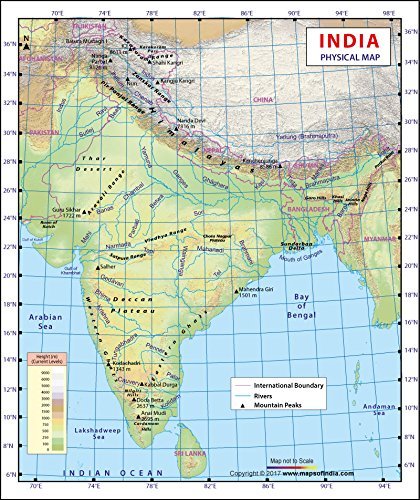
Physical Map: It show the relief features of the earth with the help of hachure’s,
contours and colours
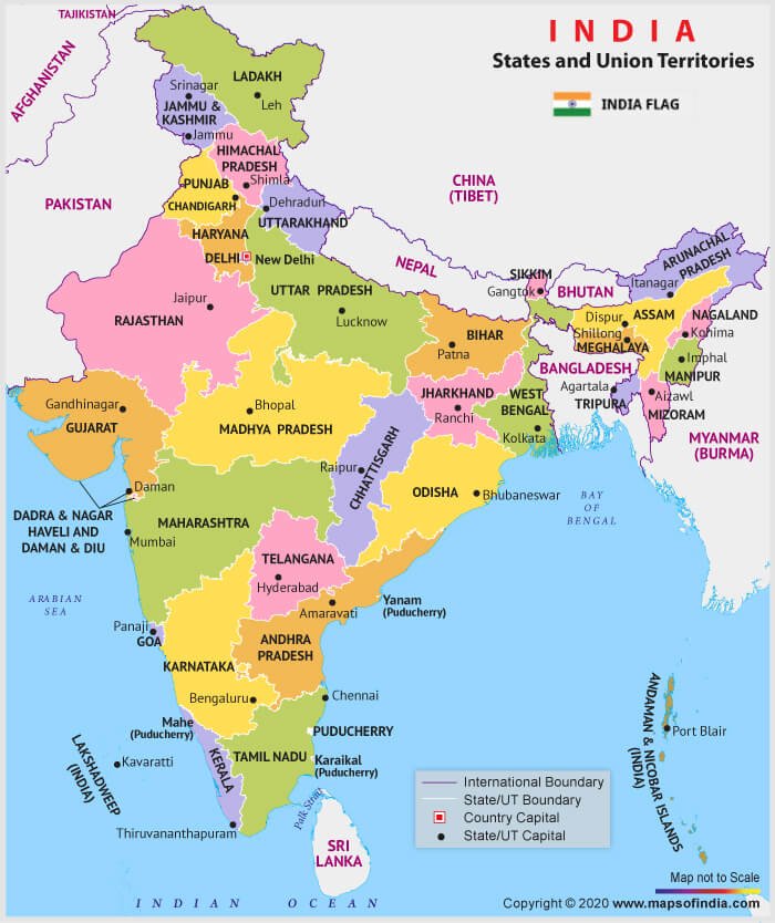
Political Map: It present a visual picture of world, continent or a country through bold
boundary lines
Statistical/Distribution Map: It show physical elements like relief, atmospheric
temperature, rainfall, air pressure etc.; they may also be used to show social and
economic data e.g. agriculture, industry, trade, transport, population, settlements etc
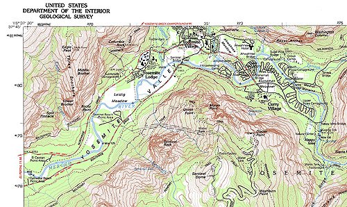
Toposheet: show physical features of the earth along with cultural aspects like settlements and transportation facilities. Such maps are useful to geographers, military
experts
Geological map: Geological maps show the rock formations, their ages, structures, mineral resources etc. They are prepared on large scales for coal fields, mining areas, engineering, geological features like dams, tunnels etc
Geomorphological Map: show the earth’s physical features, their relationship with
land, water etc. on earth’s surface; some conventional pictorial symbols are used to
show relief, landforms etc. They are normally on small scale
Cadastral map: Cadastral maps are prepared by government agencies for revenue
purposes. They show boundaries of landed properties, fields, buildings etc
Weather Map: It prepared by Meteorological Departments showing weather conditions
like distribution of atmospheric pressure, wind velocities/ directions, clouds/cloudiness,
precipitation etc
Bathymetric/Navigational Map: It show the relief of the sea floor/lake floor and are
useful for mariners; they also show the nature of the coasts, depth of water etc
Aeronautical Map: It show physiographical features of the land, airways, airports etc.
for use by pilots
Thematic Map: It is a type of map especially designed to show a particular theme connected with a specific geographic area. These maps “can portray physical, social, political, cultural, economic, sociological, agricultural, or any other aspects of a city, state, region, nation, or continent
Different methods of Thematic Mapping:
Isopleth Map: An isopleth map generalizes and simplifies data with a continuous
distribution. It shows the data as a third dimension on a map, thus isopleth maps are
more common for mapping surface elevations, amounts of precipitation, atmospheric
pressure, and numerous other measurements that can be viewed statistically as a third
dimension. It also known as Isarithmic maps
Isochronic Map: It represents the speed of travel from a central place in all directions
at some definite interval of time. E.g. flow diagram
Choropleth Map: It is a thematic map in which areas are shaded or patterned in proportion to the measurement of the statistical variable being displayed on the map, such as population density or per-capita income. It shows the level of variability within
a region. It follows the administrative boundary
Choroschematic Map: In this type of map distribution of different objects are shown
by symbols and letters. It follows the administrative boundary
Chorochromatic Map: In this type of map distribution of different objects are shown
by different colour or different sheds of one particular colour. It follows the
administrative boundary
Proportional Symbols those are used for making a thematic map:
Dot Map: It used to show distribution of rural population
Sphere Map: It used to show distribution of urban population
Proportional circle: It used to show total population, total production of different objects
Proportional Square: It used to show total number of household in a particular area
Pie Graph: It used to show different land use, production of different crops, occupational structure, composition of population
Different Instruments that used for measurements:
Planimeter: to measure area of a region from a map
Pentograph: to do enlargement and reduction of any map
Altimeter: to measure change of pressure with increase in height
Clinometer: to find dip direction and strike direction from any rock
Prismatic compass: it calculates bearings of lines with respect to magnetic north, it also use for navigation
Theodolite: surveying instrument with a rotating telescope for measuring horizontal and vertical angles
Dumpy Level: leveling instrument used to establish or verify points in the same horizontal plane. It is used in surveying with a vertical staff to measure height differences
Abney Level: to find inclination and declination of any object from eye level or surface
Rota meter: to measure length of curved line in a map
Mirror Stereoscope: to see three dimensional view of aerial photograph
Global Positioning System: It is a space-based navigation system that provides location and time information in all weather conditions, anywhere on or near the Earth where there is an unobstructed line of sight to four or more GPS satellites
Total Station: The total station is an electronic theodolite (transit) integrated with an electronic distance meter (EDM) to read slope distances from the instrument to a particular point
Sextant: It is a navigation instrument used to measure the angle between any two visible objects
How to Calculate the Scale of an Aerial Photograph
Measure the distance between two distinct features
Hints
• The two features must appear on both the map and aerial photograph.
• Use human features eg. road junctions, buildings.
• A greater distance between the two features will produce a more accurate answer.
• Try and measure a distance on the photo that is a whole number
Example: Map Scale is 1:50 000
1. Measure the direct distance between the same two points on the aerial photo eg. 10cm
2. Measure the direct distance between two points on the map eg. 6.5cm
3 . Ratio of Scales = Ratio of Distances
Scale of Photo/ = Map Distance/
Scale of Map Photo Distance
Scale of Photo /scale of map = 6.5cm/10cm
Scale of Photo = 6.5 x 50 000/10= 325 000/10= 32 500
Scale of Photo = 1: 32 500
The aerial photo has a LARGER SCALE than the map.
Scale of Photo = Map Distance
Scale of Map Photo Distance
LARGE SCALE photos or maps show a SMALLER AREA but in MORE DETAIL eg. 1:10 000
SMALL SCALE photos or maps show a LARGER AREA but in LESS DETAIL eg. 1:500 000
Welcome
More Information
Education goes beyond memorizing facts; it shapes the ability to think critically. True learning fosters curiosity, problem-solving, and creativity. A trained mind can analyze, adapt, and innovate for lifelong growth.
Edukate
Related Post
Competitive exams (W.B.C.S / U.P.S.C)
WBCS Prelims Syllabus 2025 Subject Name Marks Questions English Composition 25 25 General Science 25 25 Current events of National…
Indian Geography
INDIA AND ITS SURROUNDING Physical Aspects: Southern most latitude of India: 06o 45/ North Northern most latitude of…
Geographic Thought
Geographic Thought
“Geographic thought” as commonly understood in the discipline of geography encompasses the development of geogrpahic knowledge in particular places, time and contexts.
Philosophical Approaches
- Positivism – August Comte
- Idealism – Harris & Guelke
- Realism – Gibson
- New or Critical Realism – T.P Nunn
- Phenomenology – Relph
- Radicalism – R. Peet
- Behaviouralism – Kirk & Wolpert
- Welfare Approach- David Smith
Welcome
More Information
Education goes beyond memorizing facts; it shapes the ability to think critically. True learning fosters curiosity, problem-solving, and creativity. A trained mind can analyze, adapt, and innovate for lifelong growth.
Edukate
Related Post
Population and Settlement Geography
The study of the spatial variations in the distribution, composition, migration, and growth of population and how they are related…
Competitive exams (W.B.C.S / U.P.S.C)
WBCS Prelims Syllabus 2025 Subject Name Marks Questions English Composition 25 25 General Science 25 25 Current events of National…