
Author: Nabarun Academy
Cultural, Social and Political Geography

Education goes beyond memorizing facts; it shapes the ability to think critically. True learning fosters curiosity, problem-solving, and creativity. A trained mind can analyze, adapt, and innovate for lifelong growth.
Edukate
Related Post
Competitive exams (W.B.C.S / U.P.S.C)
WBCS Prelims Syllabus 2025 Subject Name Marks Questions English Composition 25 25 General Science 25 25 Current events of National…
Survey (Dumpy level, Prismatic campus & Theodolite)
Why NABARUN ACADEMY?We at the NABARUN ACADEMY are committed to provide a quality based education and most competent courses for…
Economic and Regional Geography
Economic and Regional Geography
Economic geography is a subdiscipline concerned with teh spatial organization and ditribution of economic activity (production, transportation, communication, and consumption); the use of the world’s resources; and the geographic origins, structure, and dynamics of the world economy.
classification of economic activites
- Primary activities :- harvest or expracted from earth, basic food production and raw materials.
- Secondary activites:- adding value to the materials. manufacturing and processing industries . lncludes construction industry and manufacturing of power.
- Tertiary activities:- link between producer adn consumer indicator of economic development
- Quaternary activites:- knowledge sector, white collar professionals working in education, government research, communication
- Quinary activities:- gold collar professions, high level decision making roles.

Welcome
More Information
Education goes beyond memorizing facts; it shapes the ability to think critically. True learning fosters curiosity, problem-solving, and creativity. A trained mind can analyze, adapt, and innovate for lifelong growth.
Edukate
Related Post
Competitive exams (W.B.C.S / U.P.S.C)
WBCS Prelims Syllabus 2025 Subject Name Marks Questions English Composition 25 25 General Science 25 25 Current events of National…
Population and Settlement Geography
The study of the spatial variations in the distribution, composition, migration, and growth of population and how they are related…
Environmental Geography
Environmental Geography
Environmental geography is the combination of the physical and human geography. A naturel resources is a source of wealth coming from our planet. peple can use resources for their advantage. we can use resourcs in our everyday life to drink, clean and wash
The word environmet derived from French word ‘environment’ which means ‘to surrounding’
Environment geography is the systematic description of different components of environment and interacting of man with it’s components.
welcome
More Inoformation
Coming Soon…
Education goes beyond memorizing facts; it shapes the ability to think critically. True learning fosters curiosity, problem-solving, and creativity. A trained mind can analyze, adapt, and innovate for lifelong growth.
Edukate
Related Post
Climatology
Atmospheric composition: The effective atmosphere is up to the height of 30 km. I. Gases: Nitrogen (78.08%) and Oxygen…
B.A / B.Sc Entrance
Study of Geography has been one of the most crucial subject in the modern times. At the moment when the…
Population and Settlement Geography
The study of the spatial variations in the distribution, composition, migration, and growth of population and how they are related to the nature of places.
Acc. To Trewartha ” The essence od population geography lies in the understanding of regional differences in the earth’s covering of people.”
John I. Clarke ” Population geography is concemed with demonstraing how spatial variation in the distribution, composition , migration and growth of population are related to the spatial variations in the nature of places.”
what is a settlement ?
A settlement is a place where people live. the function of a settlement is why it was built, Different type of settlemet have different types of functions. A site of a settlement is where it was built. there are also different settlement patterns which are nucleated, dispersed and linear.
- Demographic Transition Theory
Given by- WS Thompson in 1929 and revised by Frank Notestein in 1945
Based on – fertility, mortality and consequent change in population
Five stages in demographic transition theory
1. Stage I- High birth and high death rate
2. Stage II- High birth rate and low death rate
3. Stage III- Declining Birth rate and stable death rate
4. Stage IV – Low Birth rate and Low death rate
5. Stage V- Very low birth & Low death rates.
- Population Resource Regions – Ackerman (1970)
His concept of “Population, Natural Resources and Technology” was published in the American journal ‘The American Academy of Political and Social Sciences’ in 1970.
Five-fold Classification of the world’s population / resource regions
1. United States Type – USA, Canada, Australia, New Zealand etc.
2. European Type– Western, Southern and Eastern European countries and Soviet Central Asian republics, Singapore, South Korea and Japan
3. China or Egyptian Type – Egypt, Algeria, Tunisia, Morocco, Albania, Greece, Haiti, Cicely,
Guatemala, China, India, Pakistan, Bangladesh, Sri Lanka, Nepal, Afghanistan etc.
4. Brazilian Type – Indochina, Brazil, Bolivia, Venezuela, Paraguay, interior Argentina,
Central American Republics, Latin America , Cuba, north Australian territory, Equatorial Africa, etc.
5. Arctic-Desert Type -Antarctica, Greenland, northern part of North America and Eurasia, Desert region of Peru, the Amazon basin, the Sahara desert, deserts of Central Australia, Central Asia, Chile, Patagonia, etc.
Theory of Migration
1. Ravenstein’s Laws of Migration: (1885)
2. Mobility Transition Model of Zelinsky (1971)
3. Push & Pull Theory of Migration/Intervening Obstacles – Everett Lee (1965)
4. Gravity Model – John Q. Stewart
5. Principle of Least Effort – George K Zipf (1940)
6. Intervening Opportunities Model- SA Stouffer (1940)
Education goes beyond memorizing facts; it shapes the ability to think critically. True learning fosters curiosity, problem-solving, and creativity. A trained mind can analyze, adapt, and innovate for lifelong growth.
Edukate
Related Post
M.A/ M.Sc. Entrance
OUR FOCUS UNIVERSITIES Highly Trained and Experienced Faculty Well trained and experienced faculties are the most vital organ of the…
Oceanography
Oceanography
Definition of ocenography:-
According to H.A Marner , ” oceanography the scienc of the sea, includes primarily the studey of the form and nature of the oceans basins, teh characteristics of the water in these basins and the movement to which these water are subject to”
According to J. Proudma:- ” oceanography studies the fundamental principles of dynamics and themodynamics in relation to the physical and biological properties of the sea water”.
scope of oceanography
- This branch of climatology is concernd with the scope of the oceanographical knowledge to practical problem of the oceans
- It analysis the relationship of oceanography to other sciences.
- The main purpose is to find out the ways and means to make use of our knowledge for the betterment of human life and the life in the oceans. of oceans.
- oceanographic data management is the discipline ensuring that oceanographic data both past and present are available to researchsers.
Theories of Coral Formation:
- Subsidence Theory (1837)– C. Darwin
- Stand Still Theory (1880) – Murray
- Glacial Control Theory (1915) – Daly
Theories of Origin of Tides
- Equilibrium Theory (1687) – Isaac Newton
- Dynamical Theory (1755) – Laplace
- Progressive Wave Theory (1833) – William Whewell
- Canal Theory (1842) – G.B. Airy
- Stationary Wave Theory (1904)- R.A. Harris
Welcome
More Information
Education goes beyond memorizing facts; it shapes the ability to think critically. True learning fosters curiosity, problem-solving, and creativity. A trained mind can analyze, adapt, and innovate for lifelong growth.
Edukate
Related Post
NET/ SET /JRF
The December 2019 UGC NET examination in Geography will consists of two question papers i.e. paper-1 and paper-2 through Computer…
Climatology
Climatology
It is difined as a scientific study of climate. It discover, describes and interprets the climate on the basis of causes processes that generate them or climatology is the sicence which studies average condition of weather or the state behaviour of the atmosphere over a place or region for a long period of time .
Trewartha. ” climate represents a composite of hte day to day weather condition, and of the atmospheric elenents. within a speciifed area over a long period of time .It is more than ‘average weather for no adequate concept of climate is possible without an appreciation of seasonal and diurnal change and the succession of weather episodes generated by mobile atmospheric disturbances . while in a study of climate emphsis may be given to the average, still departures, variations, and expremes are also important”.
Atmosphere
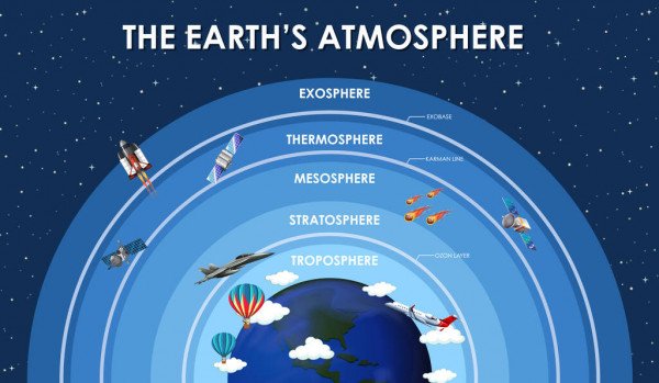
An atmosphere is a layer of gas or layers of gases that envelope a planet, and is held in place by the gravity of the planetary body. A planet retains an atmosphere when the gravity is great and the temperature of the atmosphere is low.
Atmospheric composition:
The effective atmosphere is up to the height of 30 km.
I. Gases: Nitrogen (78.08%) and Oxygen (20.95%) are the chief components of the total
gaseous composition of the atmosphere. The remaining 1% is represented by Argon
(0.93%), Carbon dioxide (0.03%), Neon (0.0018%), Ozone (0.00006%), Helium
(0.00005%), Krypton, Xenon, Methane and water vapour. The vapour content in the
atmosphere ranges between 0 to 5% by volume. More than 90% of the total atmospheric
vapour we found up to the height of 5 km.
II. Liquid Elements: Small water droplets
III.Solid Elements: This include dust particles, salt particles, pollen smoke, volcanic ashes, ice
crystals etc. Most of these particles are kept in suspension in the atmosphere. Those
particulate matters are known as ‘Aerosols’. The sky appears blue due to selective scattering
of solar radiation by dust particle.
Layering of Atmosphere (on the basis of temperature):
Troposphere:
Lower most layer of atmosphere. Troposphere means ‘always changeable zone’
All the atmospheric phenomena like rainfall, snowfall, storms, fog occurs here
This layer is known as ‘Layer of Disturbance’
In this layer temperature decrease with increase in height, known as Normal Lapse Rate
(6.4°C/km)
At the top most part of troposphere temperature ranges from (-) 57°C to (-) 60°C
Height of troposphere is maximum at equator (18 km) while it is minimum at the poles (8 km)
75% of gaseous elements and 90% of aerosols are situated in this layer
Air pressure and Density is maximum in this layer
Tropopause is a transitional zone situated between Troposphere and Stratosphere
Stratosphere:
It is extended up to 50 km from the uppermost portion of tropopause
It is known as ‘Sphere of Calm’
Mother of pearl cloud or Nacreous cloud can be observed n this layer.
In this layer temperature increases with increase in height
Temperature reaches at 0°C to top most portion of this layer
Pilots prefer to fly in the stratosphere
From 30 km to 50 km in this layer dominance of ozone gas has found. That particular portion
of this layer is known as ‘Ozonosphere’, it absorbs Ultra violet ray coming from sun
Stratopause is a transitional zone situated between Stratosphere and Mesosphere
Mesosphere:
This layer is started from 50 km and extended up to 80 km
In this layer temperature decrease with increase in height, temperature at topmost portion: (-100°C)
Coolest layer of atmosphere
It is also the layer where most meteors burn up upon atmospheric entrance
Mesopause a transitional zone situated between Mesosphere and Ionosphere
Thermosphere:
Another names are Ionosphere and Isothermal region This layer is started from 80 km and extended up to 500 km Lower portion of thermosphere is known as ionosphere (80km – 400km), high electron density is observed.
Ionosphere can be divided into 3 layers – D layer: Lower most layer of ionosphere (80 km – 90 km). In this layer Nitric Acid (HNO3) ionized Nitric Oxide (NO) E layer: Extension 90 km to 120 km. Also known as Kennelly Heaviside Layer. In this layer X-ray ionized atomic oxygen which has wave length < 1 - 10 nanometer. F layer: Lower most layer of ionosphere (120 km – 400 km). Also known as ‘Appleton Layer’.In this layer UV-ray ionized oxygen molecule.
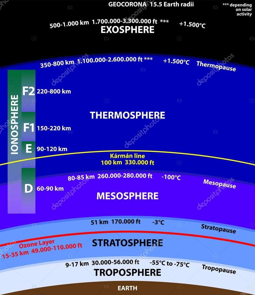
Upper portion of thermosphere is known as isothermal region (400 km – 500 km.
The electrical connectivity is responsible for reflecting radio waves back from ionosphere
Temperature rises up to 1200°C at the top most portion of this layer
This layer is completely cloudless and free of water vapour
Aurora borealis and Aurora australis are occasionally seen in ionosphere.
The International Space Station orbits in this layer, between 320 and 380 km
Thermopause is situated between Ionosphere and Exosphere
Exosphere:
It is extended up to 1000 km from the uppermost portion of thermopause
Lower portion of exosphere is known as exobase.
Main constituents of this layer are atoms of Oxygen, Hydrogen and Helium
Magnetosphere:
Uppermost layer of atmosphere, starts from 1000 km
Consist of ‘+ve’ charged protons and ‘–ve’ charged electrons known as Van Allen radiation belt
Upper portion of magnetosphere is known as Magnetopause which looks like a ‘bullet’.
Layering of Atmosphere (on the basis of composition):
Homosphere:
It starts from troposphere and extended up to mesosphere.
Extension: up to 80 km
Heterosphere:
It starts from thermosphere and extended up to magnetosphere.
Extension: 80 km – 10,000 km
It has 4 subdivisions –
i. Atomic Nitrogen Layer (80 km – 200 km)
ii. Oxygen Molecule Layer (200 km – 1100 km)
iii. Helium Layer (1100 km – 3500 km)
iv. Hydrogen Layer (3500 km – 10,000 km)
Weather Measuring instruments:
for measuring air and sea surface temperature – Thermometer
for measuring atmospheric pressure – Barometer [‘Baros’ means Pressure]
for measuring humidity – Hygrometer
for measuring wind speed – Anemometer
for measuring solar radiation – Pyranometer
for measuring amount of rainfall – Rain Gauge
for determine direction of wind – Wind Vane
for measuring relative humidity – Sling Psychrometer
Different Isolines used in Climatology:
- Isobar – Equal pressure line 6. Isonif – Equal snowfall line
- Isohel – Equal solar insolation line 7. Isorysm – Equal intensity of snowfall line
- Isohyet – Equal rainfall line 8. Isotherm – Equal temperature line
- Isomer – Equal average rainfall line 9. Isonomaly – Equal inequality line
- Isoneph – Equal cloud cover line 10. Isoterp – Equal degree of climatic comfort line
Rainfall Formation Theories
i. Cloud Instability Theory/Ice Crystal Theory of Bergeron Findeisen (1933)
ii. Collision Coalescence Theory- Walter Findeisen
Anti-Cyclone
Sir Francis Galton 1861
Polar Front Theory (Temperate Cyclone)
V. Bjerknes and J. Bjerknes
Airmass
V. Bjerknes and J. Bjerknes
Jeat Stream
C.G Rossby -1947
Welcome
More Information
Education goes beyond memorizing facts; it shapes the ability to think critically. True learning fosters curiosity, problem-solving, and creativity. A trained mind can analyze, adapt, and innovate for lifelong growth.
Edukate
Related Post
Geographic Thought
Philosophical Approaches Positivism – August Comte Idealism – Harris & Guelke Realism – Gibson New or Critical Realism – T.P…
Rocks and Minerals
Why NABARUN ACADEMY?We at the NABARUN ACADEMY are committed to provide a quality based education and most competent courses for…
Geomorphology
Geomorphology
- Definition of geomorphology is significant branch of physical geography ( geomorphology, oceanography, climatology and biogeography). The term geomorphology stems from three greek words i.e ‘geo’(meaning earth), ‘morphe’ (from) and ‘logos’ ( a discourse). Geomorphology, therefore, is defined as the science of description (discourse ) of various forms (morphe) of the earth’s surface .To be more precise, forms mean topographic features or geometric features (relief features) of the earth’s surface.
P.G Worcester (1940) preferred of define geomorphology as the interpretative description of the relief features of the earth’s surface while
W.D Thornbury (1954) pleaded for the inclusion of submarine forms in addition to surface reliefs in the realm of geomorphology.
A.L Bloom (1979) also defined geomorphology as the systematic description and analysis of landscape and the processes that change them.
Catastrophism is the theory that the earth
has largely been shaped by sudden, short lived, violent events, possibly worldwide in
scope.
The concept was first popularized by the
early 19th century French scientist Georges
Cuvier.
Example-volcanoes, floods, and
earthquakes
Uniformitarianism:-The theory that changes in the earth’s crust during geological history have resulted form the action of continuous and uniform processes
• Example– Given a long period of time, a river can erode a valley. Based on the principle of uniformitarianism, all valleys in the past have been formed by rivers eroding them and all future valleys will be formed this same way.
Eearthquake
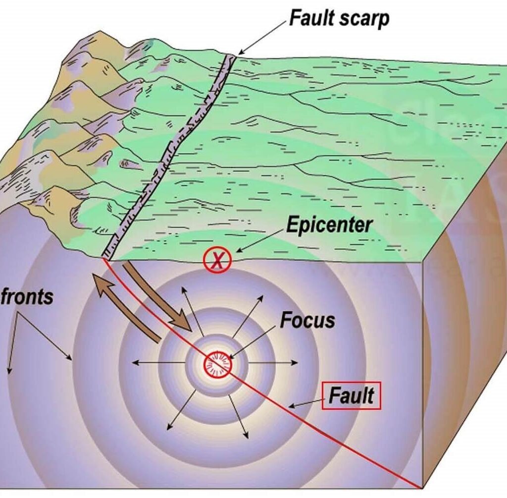
Oscillation or vibration of the surface of earth is known as Earthquake
The place of the origin of the earthquake is called ‘focus’ or ‘centre’ which is hidden inside the earth’s surface
The place on the ground surface which is perpendicular to the buried focus is called ‘epicenter’
Focus or center of earthquake situated around 5 km – 700 km under the surface
Classification of earthquake on the basis of depth of focus:
i. Shallow Depth Focus – Within 50 km
ii. Medium Depth Focus – 50 to 300 km
iii. Deep Depth Focus – 300 to 700 km
Seismic waves are recorded by an instrument called ‘seismograph’ (by John Milne in 1880)
Energy released by earthquake, spread in form of wave which is known as seismic wave
Intensity of earthquake is maximum between 15 km – 35 km under the surface
Over the surface maximum intensity of earthquake is in epicenter
Intensity of earthquake gradually decrease while distance from epicenter increases
Line joining places which experiences the earthquake at the same time is known as
Homoseismal Line
Line joining places which experiences the same intensity of earthquake is known as
Isoseismal Line or Isodiastrophic Line
Earthquake with low intensity is termed as Tremor
Intensity of earthquake is measured by Mercalli scale, invented by Giuseppe Mercalli in 1931
Magnitude of earthquake is measured by Richter scale, invented by Charles Richter in 1935
In Richter scale which earthquake measured by 6 is 10 times stronger than earthquake marked by 5 and 100 times stronger than earthquake marked by 4
A value of 9.6 in Richter scale is the largest observed earthquake till now in Chile in 22nd May
Types of Seismic Waves: P wave, S wave and L wave
P wave –
I. P wave is also known as Primary wave or Push wave
II. ‘P’ is the first wave that captured by seismograph
III. P wave is an example of longitudinal wave
IV. It has minimum wave length among the three waves
V. It is the fastest wave among three (5 km – 14 km per second)
VI. It can penetrate through all state of matter (solid, liquid and gas)
VII. When density of lithosphere is homogenous then P wave passes through in a straight line
VIII. When density of lithosphere is heterogeneous then P wave reflected from its own path
S wave –
I. After P wave S wave or Secondary wave captured by seismograph
II. Speed of S wave is 3.5 km – 7.2 km per second
III. S wave is an example of Latitudinal wave
IV. It only can penetrate through solid state of matter
V. It can’t penetrate through outer mantle due to its liquid state
L wave –
I. At the last stage L wave or Long wave captured by seismograph
II. L wave is also known as Surface wave
III. It is an example of transverse wave
IV. It has maximum wave length but minimum speed (3 km per second)
V. It only can penetrate through solid state of matter
VI. It cause most of the destruction over earth surface
VII. It only spread through the earth’s surface
L wave can be divided into two division:
i. Love wave – This surface wave move ahead in horizontal motion.
ii. Rayleigh wave – This surface wave which move ahead in a elliptical motion.
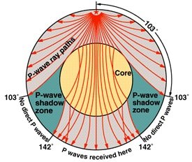
Shadow Zone – Region between 104° – 140° angular distance from epicenter is known as
shadow zone of earthquake because no effect of earthquake observed because of refraction of
P wave and absorption of S wave . Shadow zone situated between 11,540 km – 15,940 km
from epicenter
Primary and Secondary wave also known as Body Wave
Causes of Earthquake:
Tectonic Causes – Plate movement (main causes of earthquake), Contraction of earth’s
surface, Upliftment of folded mountain, Volcanisity, Isostatic adjustment 95%
earthquake occurs due to tectonic causes.
Non-tectonic Causes – Slide, Avalanche, Fall of meteors
Man made Causes – Atomic bomb blast, Blasting in mines, Construction work in
mountainous region
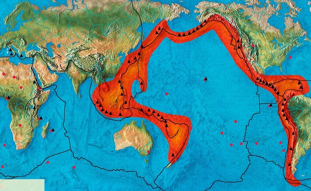
Earthquake prone belt in world:
a) Circum Pacific Belt – 68% earthquake occurs here. This region is also known as ‘Ring
of Fire’. It consist Chile, California, Alaska, Japan, Philippines and New Zealand
b) Alps Himalayan / Tethys / Mid World Mountain Belt – 21% earthquake occurs here
c) Mid Atlantic Oceanic Ridge and African Rift Valley Belt – 11% earthquake occurs here
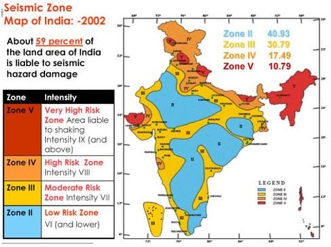
Earthquake Prone Regions of India:
a) Very High Earthquake Prone – Jammu and Kashmir, North East India, Kutch of
Gujarat, Andaman and Nicobar Island
b) High Earthquake Prone – Northern Plain, Delhi, Maharashtra, West Bengal
c) Moderate Earthquake Prone –Ahmadabad, Uttar Pradesh, Madhya Pradesh,
Lakshadweep, Andhra Pradesh
d) Low Earthquake Prone – Tamil Nadu, Rajasthan, Orissa, Karnataka
About 80% volcanoes are associated with convergent plate boundary.
About 15% volcanoes are associated with divergent plate boundary.
Maximum volcanicity occurs in mid oceanic ridge region.
Maximum earthquake occurs in oceanic trench regions.
Welcome
More Information
Education goes beyond memorizing facts; it shapes the ability to think critically. True learning fosters curiosity, problem-solving, and creativity. A trained mind can analyze, adapt, and innovate for lifelong growth.
Edukate
Related Post
Rocks and Minerals
Why NABARUN ACADEMY?We at the NABARUN ACADEMY are committed to provide a quality based education and most competent courses for…
Population and Settlement Geography
The study of the spatial variations in the distribution, composition, migration, and growth of population and how they are related…
NET/ SET /JRF
Education goes beyond memorizing facts; it shapes the ability to think critically. True learning fosters curiosity, problem-solving, and creativity. A trained mind can analyze, adapt, and innovate for lifelong growth.
Edukate
Related Post
Geomorphology
P.G Worcester (1940) preferred of define geomorphology as the interpretative description of the relief features of the earth’s surface while…
Competitive exams (W.B.C.S / U.P.S.C)
WBCS Prelims Syllabus 2025 Subject Name Marks Questions English Composition 25 25 General Science 25 25 Current events of National…
Rocks and Minerals
Why NABARUN ACADEMY?
We at the NABARUN ACADEMY are committed to provide a quality based education and most competent courses for our students, so that they can easily and confidently compete in the present scenario. We’re focused to enhanced both technical/practical and professional quality of our students’. We are committed to provide a healthy and competitive environment with all the required facilities.
COURSE CONTENT ROCK AND MENAREL
A. Measurement of dip and strike using clinometer
B. Megascopic identification of Mineral and Rock.
- Mineral Samples:
- Bauxite
- Calcite
- Chalcopyrite
- Feldspar
- Galena
- Gypsum
- Hematite
- Magnetite
- Mica
- Quartz
- Talc
- Tourmaline
- Rock Samples:
Granite
Basalt
Dolerite
Laterite
Limestone
Shale
Sandstone
Conglomerate
Slate
Phyllite
Schist
Gneiss
Quartzite
Marble
CONURSE DURATION :- ONE MONTHE
COURSE FEES :-2000/-
Education goes beyond memorizing facts; it shapes the ability to think critically. True learning fosters curiosity, problem-solving, and creativity. A trained mind can analyze, adapt, and innovate for lifelong growth.
Edukate
Related Post
Geographic Thought
Philosophical Approaches Positivism – August Comte Idealism – Harris & Guelke Realism – Gibson New or Critical Realism – T.P…
Geomorphology
P.G Worcester (1940) preferred of define geomorphology as the interpretative description of the relief features of the earth’s surface while…
GIS & Remote Sensing (Geoinformatics)
The modern world GIS & Remote sensing service is on the rise day by day. Now this field of study is a multidisciplinary one. It covers the various aspects of Geography, Geology, and informatics. This course offers a wide scope with accelerated growth and development prospects.
COURSE -I
- COMPUTER APPLICATION IN GEOGRAPHY
- Introduction of computer, Processing of data, Number system
- Microsoft word, Microsoft excel, Basic concepts of database
- E- Resources in Geography
- GEOGRAPHICAL INFORMATION SYSTEM
- Definition and evolution of GIS: Components of GIS; Geographical data: types and characteristics; Earth’s shape, coordinate systems and datum
- Digital representation of geographical data: data structure, spatial data model, database management systems, raster and vector models.
- Digital Elevation Model (DEM): Characteristics and applications; Remote sensing and GIS integration;
- GIS Data Analysis: Input; Geo-Referencing; Editing, Output and Query; Overlays by QGIS Software
- GLOBAL POSITIONING SYSTEM (GPS):
- Global Positioning System (GPS): principles, uses and applications.
COURSE DURATION : Three months
COURSE FEES : 5,000/-
COURSE –II
- Image georeferencing and enhancement. Preparation of reflectance libraries of LULC features across different image bands of IRS L3 or Landsat OLI data
- Supervised image classification, class editing and post-classification analysis
- Digitisation of features and administrative boundaries. Data attachment, overlay and preparation of annotated thematic maps
- Waypoint collection from GNSS receivers and exporting to GIS database
COURSE DURATION : – Two months
COURE FEES :-2000/-
COURSE –III (ArcGIS)
- What is ArcGIS?
- ArcGIS Desktop
- Data management with catalog
- Metadata and supported data formats in ArcGIS
- Understanding the geodatabase
- Geoprocessing
- An overview of ArcMap
- An overview of Map Edition and data Compilation
- Map query and geocoding
- Map layout, chart and report?
- Animation in ArcGIS?
- Network analysis
- 3D Analysis in ArcGIS
- Spatial Analysis in AarGIS
- ArcScan –Automatic raster to vector conversion
COURSE DURATION :- Four months
COURSE FEES :-10,000/-
Education goes beyond memorizing facts; it shapes the ability to think critically. True learning fosters curiosity, problem-solving, and creativity. A trained mind can analyze, adapt, and innovate for lifelong growth.
Edukate
Related Post
Oceanography
scope of oceanography This branch of climatology is concernd with the scope of the oceanographical knowledge to practical problem of…